Thailands Plate Tectonic Relationship
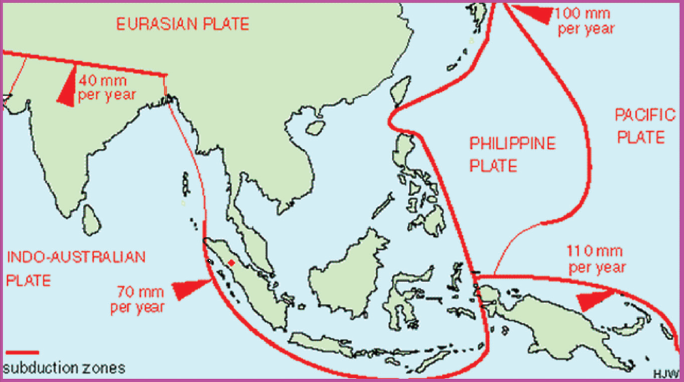
Thailand is located on the Eurasian tectonic plate and is surrounded by the Indo-australian and Philippines/Pacific plate. While the country is not directly on any tectonic boundary it is still affected by the converging of the plates mentioned before. Since it's close, but not to close to a boundary, Thailand still experiences earthquakes, but none over a magnitude of 6.3 have ever been recorded; it would be considered low to moderate risk for minor earthquakes. The plates shifting have affected the topography of the country over many years through subduction specifically the southern coast, northern mountains, and the Khorat Plateau all caused by the shifting of the tectonic plates or the continents. While not often affected by the shifting of tectonic plates, there is still risk for tsunamis as seen in 2004 during the Indian Ocean Tsunami that struck the south coast of Thailand. This disaster took the lives of over 4,000 people and left almost 15,000 injured or missing. The tectonic plates have played a vast role in forming the geography of modern Thailand, yet there is no longer immediate risk of the dangers converging plates causes.

The most common causes for natural hazards in Thailand is human involvement(climate change), and storms. Over the last several years the most prominent danger for citizens of Thailand has been flooding caused by heavy rainfall. In a lot of these cases they also experienced terrible landslides due to the soft makeup of a lot of ground such as sand and soft dirts. Aside from flooding, areas of Thailand are also prone to drought because of the soils makeup and climate change slowly increasing temperatures drying out the land. Although they are on opposite sides of the spectrum the topography of this nation can help understand the nature of the flooding and droughts. I believe most people tend to notice the extreme temperatures the most when visiting, as natural disasters are possible but not alarmingly frequent.

Here is a topographical map of Thailand so you can better see the large area the mountain ranges cover in the north. You can also kinda see the Khorat Plateau in the north-east and how it is slightly raised above the center of the country.
Down here in the south is where the tsunami of 2004 hit and a few other typhoons caused by the converging and subducting of the tectonic plates.
References:
Topographical Map - https://www.mapsland.com/asia/thailand/detailed-topographic-map-of-thailand-with-other-marks
Tectonic Plate Close Up - http://www.cicc.chula.ac.th/eng/2012-04-26-04-23-32/111-likelihood-of-earthquakes-in-thailand.html
Thailands Geographic Challenge - https://www.youtube.com/watch?v=NPbov3zeivA
Climate Change Knowledge Portal - https://climateknowledgeportal.worldbank.org/country/thailand
Tectonic and Geologic Evaluation - https://www.gsm.org.my/wp-content/uploads/gsm_file_1/SCTM_18.pdf
Tectonic and thermal Evolution -https://www.researchgate.net/publication/258699091_Tectonics_and_Thermal_evolution_of_Thailand_in_the_regional_context_of_South-East_Asia_Geology_of_Thailand
Khorat Plateau -https://www.britannica.com/science/plateau-landform/Geographic-distribution

I'm doing my tectonic plates on South Korea, Which Is also on the Eurasian belt. Similar to Thailand Korea is not too close or too far from the boundary, it is pretty stable it isn't affected too much. Also, South Korea doesn't experience high Earthquakes either very moderate to small ones as well.
ReplyDelete